Special Weather Statement: Tropical Disturbance AL94 Issued at 12:00 EDT, Friday 26th September, 2025
BAHAMAS DEPARTMENT OF METEOROLOGY FORECAST OFFICE SECTION
P. O. BOX N-8330 TELEPHONE No. 702-5250/1 NASSAU, BAHAMAS
Website: https://met.gov.bs Email: meteo@batelnet.bs
FILE NO: 7.6A
Special Weather Statement: Tropical Disturbance AL94
Issued at 12:00 EDT, Friday 26th September, 2025
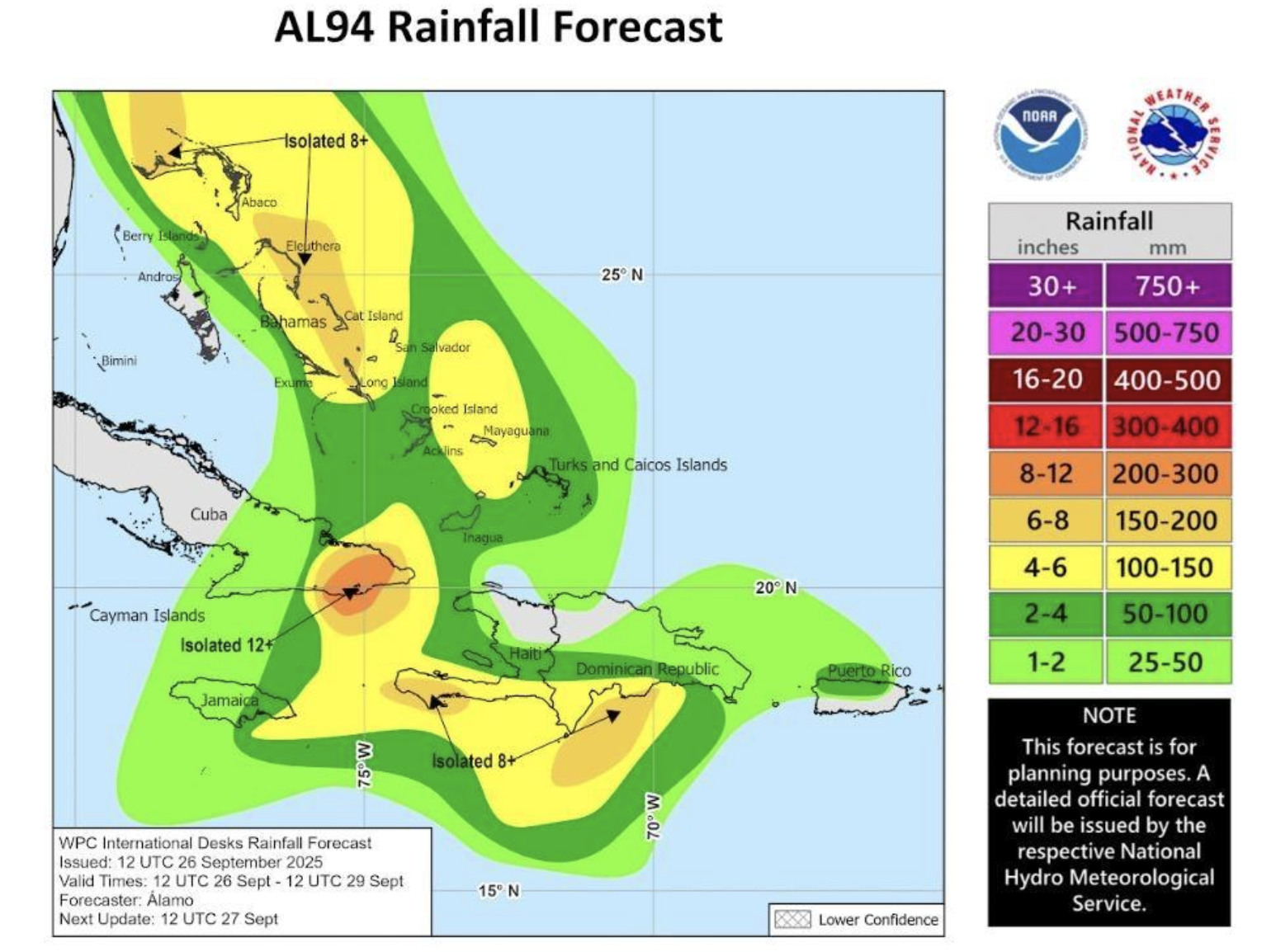
The Bahamas Department of Meteorology continues to closely monitor an active tropical wave (AL94), now located north of Hispaniola and just south of the Turks and Caicos Islands. The showers and thunderstorms associated with this system continue to show signs of organization. An area of low pressure has a very high chance of forming along the wave by tonight when it moves near or over the Southeast Bahamas. This low is then expected to become a tropical depression when it is in the vicinity of the Central and Northwest Bahamas on Saturday and Sunday, and then track northwestward or northward over the southwestern Atlantic. Some uncertainty still remains relating to the intensity of the disturbance, once the system develops in The Bahamas. However, there is greater confidence that the system will attain at least Tropical Storm status.
Residents of San Salvador, Rum Cay, Long Island, Cat Island, Exuma and its Cays should begin preparations for Tropical Storm conditions beginning Saturday.
Residents in Eleuthera, New Providence, the Berry Islands, Abaco and its Cays as well as Grand Bahama and its Cays should begin making preparations for possible Tropical Storm or Hurricane conditions on Sunday.
Residents in Inagua, Mayaguana, Acklins, Crooked Island, Long Cay, Ragged Island and the Turks and Caicos Islands should have already made preparations for the possibility of a tropical depression later this evening. These islands can expect widespread showers, severe thunderstorms and strong winds gusting to gale force or higher with possible tornadic activity. These islands will remain under a severe weather warning throughout the weekend.
For the Northwest and Central Bahamas, rainfall amounts are anticipated to be between 4 to 6 inches with isolated amounts up to 8 to 10 over the next 3 days. For the Southeast Bahamas and the Turks and Caicos Islands, rainfall amounts are anticipated to be between 2 to 4 inches, with isolated amounts of up to 6 inches over the next 3 days.
Please be advised that the Bahamas Department of Meteorology will continue to closely monitor this tropical disturbance, and update the public on any new developments. Residents in the remainder of the Bahamas are asked to continue to pay special attention to all communications and forecasts issued by the Bahamas Department of Meteorology on this system, as any development into a tropical depression or storm may also impact this area.
Issued by: The Bahamas Department of Meteorology