Alert #8 on Tropical Depression Nine issued by The Bahamas Department of Meteorology, Saturday September 27th, 2025, at 3PM EDT.
BAHAMAS DEPARTMENT OF METEOROLOGY
Forecast Office Section Telephone No. 377-7178/377-7040 Fax No. 377-5275
Nassau, Bahamas
Alert #8 on Tropical Depression Nine issued by The Bahamas Department of Meteorology, Saturday September 27th, 2025, at 3PM EDT.
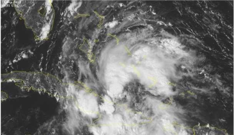
...HEAVY RAINS CONTINUE OVER PORTIONS OF EASTERN CUBA AND THE BAHAMAS...
...AIR FORCE HURRICANE HUNTERS EN ROUTE TO INVESTIGATE THE SYSTEM...
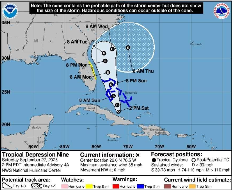
A Tropical Storm Warning remains in effect for the islands of the Northwest and Central Bahamas. This includes the islands of Eleuthera, New Providence, Abaco, Andros, Berry Islands, Grand Bahama San Salvador, Rum Cay, Long Island, Exuma and its Cays and Cat Island.
Tropical Storm Warning means that Tropical Storm Conditions are expected somewhere within the warning area within 36 hours.
At 2 pm EDT, the center of Tropical Depression Nine was located near latitude
22.0 North, longitude 76.5 West or about 50 miles West-southwest of the Ragged Island chain, 120 miles Southwest of Deadman’s Cay, Long Island and 215 miles South-southeast of New Providence. The depression is moving toward the northwest near 6 mph (9 km/h). A north-northwestward motion is expected to begin tonight and continue through Monday. On the forecast track, the center of the system is expected to move across the central and northwestern Bahamas on Sunday and Sunday night and approach the southeast U.S. coast early next week.
Maximum sustained winds are near 35 mph (55 km/h) with higher gusts. Strengthening is expected during the next few days, and the system is forecast to become a tropical storm tonight and a hurricane by late Monday or Tuesday.
Due to a westward shift in the forecast track, the center of the system is now forecast to pass to the east of Andros and over New Providence Sunday morning and between Abaco and East Grand Bahama on Sunday night as a Tropical Storm.
Residents in the Northwest and Central Bahamas should begin to make final preparations today for the possibility of Tropical Storm conditions beginning tonight and early Sunday morning.
Rainfall amounts in the Central and Southeast Bahamas are anticipated to be between 4 to 8 inches with isolated amounts up to 10 inches. Residents in low-lying areas should take actions to mitigate property damages due to flooding.
The next Alert on Tropical Depression nine will be issued at 6pm EDT.
Issued by: Bahamas Department of Meteorology