Alert #23 on Tropical Storm Imelda issued by The Bahamas Department of Meteorology, Monday September 29 th , 2025, at 12 pm EDT.
BAHAMAS DEPARTMENT OF METEOROLOGY
Forecast Office Section
Telephone No. 377-7178/377-7040
Fax No. 377-5275
Nassau, Bahamas
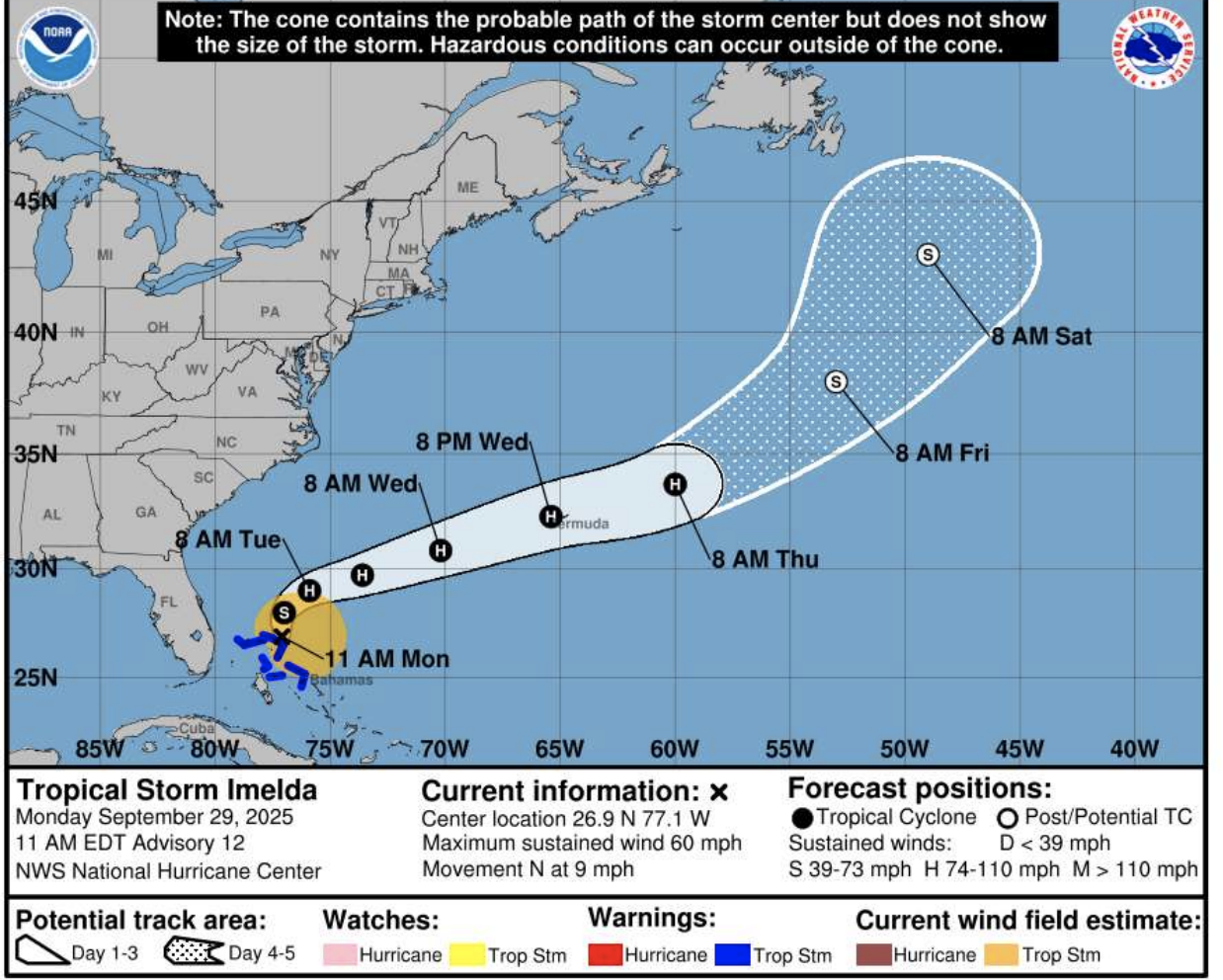
Alert #23 on Tropical Storm Imelda issued by The Bahamas Department of Meteorology, Monday September 29 th , 2025, at 12 pm EDT.
.…Tropical storm conditions continue over the Extreme Northwest Bahamas and Imelda is forecast to become a Hurricane on Tuesday…
Tropical Storm Warning is discontinued for the Central Bahamas and parts of the Northwest Bahamas. The All Clear is therefore given for New Providence, Andros, Berry Islands, San Salvador, Rum Cay, Long Island, Exuma and its Cays and Cat Island.
The All Clear means that these islands will no longer be impacted by Tropical Storm conditions. However, Heavy rain with isolated thunderstorms and gusty winds can still be experienced as a result of outer bands from Imelda. A Tropical Storm Warning remains in effect for the islands of the Extreme Northwest Bahamas.
This includes the islands of Eleuthera, Abaco, Grand Bahama and all surrounding Cays. Tropical Storm Warning means that Tropical Storm Conditions are expected somewhere within the warning area within 36 hours. At 11 am EDT, the center of Tropical Storm Imelda was located near latitude 26.9 degrees north and longitude 77.1 degrees west, or about 101 miles Northnorthwest of Spanish Wells, Eleuthera, 64 miles Northeast of Sandy Point, Abaco, 26 miles North of Marsh Harbor, Abaco, 54 miles East of East End Grand Bahama and 130 miles Northeast of New Providence. Imelda is moving toward the north near 9 miles-per-hour, and a generally northward motion is expected to continue today.
On Tuesday, Imelda is expected to turn sharply to the east-northeast. On the forecast track, the center of the system is expected to move away from the Northwest Bahamas and out of The Bahamas by tonight.
Maximum sustained winds are near 60 miles-per-hour with higher gusts. Strengthening is forecast and Imelda could become a Hurricane on Tuesday. Tropical Storm force winds extend outwards up to 175 miles mainly to the east of the center. Moderate to heavy rainfall is now being experienced over Abaco, Grand Bahama and Eleuthera and is expected to continue through today. Even though the All Clear is given for the islands of New Providence, Andros, Berry Islands, San Salvador, Rum Cay, Long Island, Exuma and its Cays and Cat Island, there will continue to be scattered showers, isolated thunderstorms and gusty winds throughout today.
Residents in these islands should also be aware that due to the excessive rainfall experienced during the past several days, there are areas of extreme flooding throughout the islands and should exercise caution. Rainfall amounts in the Northern and Northwest are anticipated to be between 4 to 8 inches with isolated amounts up to 10 inches, and 2 to 4 inches in the Central and Southeast Bahamas and isolated amounts up to 6 inches. Storm surge will raise water levels 1 to 3 feet above normal tide along the coast of Abaco, the north and east coasts of Grand Bahamas, and all nearby Cays today.
The next Alert on Tropical Storm Imelda will be issued at 3 PM EDT.
Issued by: ANASTASHIA FERNANDER/ANTONY RAHMING