Alert #2 on Potential Tropical Cyclone Nine issued by The Bahamas Department of Meteorology, Friday September 26th, 2025, at 9pm EDT.
BAHAMAS DEPARTMENT OF METEOROLOGY FORECAST OFFICE SECTION
P.O. BOX N-8330 TELEPHONE No. 702-5250/1 NASSAU, BAHAMAS
Website: https://met.gov.bs Email: meteo@batelnet.bs FILE NO: 7.6A
Alert #2 on Potential Tropical Cyclone Nine issued by The Bahamas Department of Meteorology, Friday September 26th, 2025, at 9pm EDT.
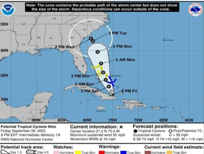
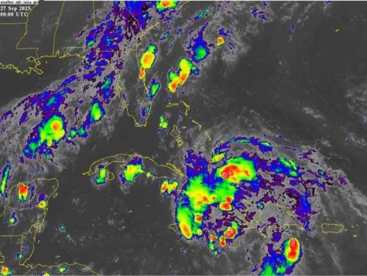
...Disturbance remains west of Inagua...
...Significant rainfall expected over portions of eastern Cuba and The Bahamas through the weekend...
A Tropical Storm Warning remains in effect for the islands of the Central Bahamas. This includes the islands of San Salvador, Rum Cay, Long Island, Exuma and its Cays along with Cat Island.
A Tropical Storm Watch remains in effect for the islands of the Northwest Bahamas. This includes the islands of Eleuthera, New Providence, Abaco, Berry Islands, Grand Bahama and all Cays surrounding these islands.
A Tropical Storm Warning means that Tropical Storm conditions are expected somewhere within the warning area within 36 hours.
A Tropical Storm Watch means that Tropical Storm conditions are possible within the watch area, generally within 48 hours.
At 8 pm EDT, the center of Potential Tropical Cyclone Nine was located near latitude 21.0 degrees north and longitude 75.0 degrees west, or about 85 miles West of Matthew Town, Inagua, 150 miles South of Deadman’s Cay, Long Island and 310 miles South-southeast of New Providence.
The system is moving toward the northwest near 10 miles-per-hour.
A northwestward to north-northwestward motion is expected during the next few days. On the forecast track, the center of the system is expected to move across the Central and Northwestern Bahamas this weekend and approach the southeast U.S. coast early next week.
Maximum sustained winds are near 35 miles-per-hour with higher gusts. Gradual strengthening is forecast, and the system is expected to become a Tropical Depression on Saturday and a Tropical Storm Saturday night or early Sunday.
Residents in the Central Bahamas should begin to make preparation for the possibility of Tropical Storm conditions beginning on Saturday night and early Sunday morning. Tropical Storm conditions are expected to spread into the Northwest Bahamas on Sunday morning and into the Abaco and Grand Bahama area by Sunday afternoon.
Rainfall amounts in the Central and Southeast Bahamas are anticipated to be between 4 to 6 inches with isolated amounts up to 8 to 10 inches. Residents in low-lying areas should take actions to mitigate against property damages due to flooding.
Small craft operators throughout The Bahamas should remain in port as large swells and battering waves will affect The Bahamas during the next few days.
The next Alert on Potential Tropical Cyclone Nine will be issued at 12am EDT Saturday.
Issued by: Bahamas Department of Meteorology