Alert #23 on Hurricane Isaias

Bahamas Department of Meteorology
Forecast Office Section Telephone No. 377-7178/377-7040
Fax No. 377-5275 Nassau, Bahamas
Hurricane hunters find Isaias getting better organized. Tropical storm conditions and heavy rains spreading into the central Bahamas.
Hurricane warning has been discontinued for Inagua island and the Turks & Caicos Islands. Hurricane warning remains in effect for the remainder of the Bahamas.
A hurricane warning means that hurricane conditions are being experienced or could be experienced somewhere in the warning area within 36 hours.
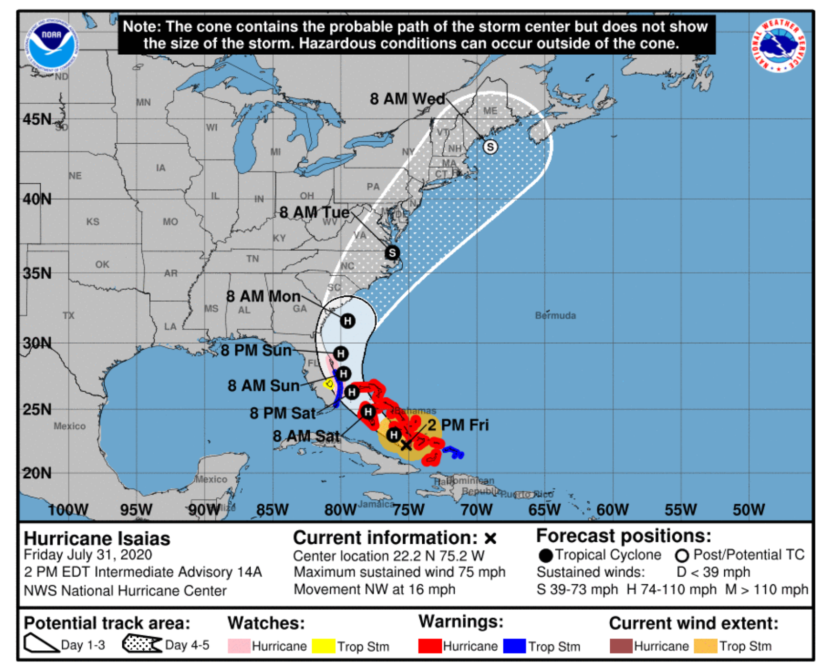
At 2 pm EDT, the center of Isaias was located near latitude 22.2 degrees north and longitude 75.2 degrees west or about 62 miles west of salina point, Acklins or 64 miles south-southwest of clarence town, long island or 98 miles south-southeast of Georgetown, Exuma or 205 miles south-southeast of congo town south Andros and 240 miles south-southeast of new providence.
Isaias is moving toward the northwest near 16 mph, and a general northwestward motion with some decrease in forward speed is expected for the next day or so followed by a turn toward the north-northwest.
On the forecast track, the center of Isaias will continue to move into the central Bahamas tonight, and move over the northwest Bahamas Saturday and near the east coast of the Florida peninsula Saturday afternoon through Sunday from Inagua and will pass west of Acklins, Crooked Island, Long Island and Exuma, and east of Ragged Island today.
Isaias is expected to impact New Providence and the northwest Bahamas tonight and tomorrow.
Maximum sustained winds are near 75 mph with higher gusts. Strengthening is expected later today and tonight, and Isaias is forecast to remain a hurricane for the next few days.
Hurricane force winds extend outward up to 35 miles from the center and tropical storm force winds extend outward up to 205 miles from the center.
Storm surge of 3 to 5 feet above normal tide levels can be expected along coastal areas throughout the Bahamas.
Tropical storm and some hurricane conditions are now spreading into the central Bahamas and the northwest Bahamas later this evening and tonight. Tropical storm conditions are now being experienced in and around Crooked Island and Acklins and conditions are continuing to subside over the Turks and Caicos Islands.
Localized flooding is expected throughout the Bahamas and the Turks and Caicos Islands as Isaias is forecast to produce rainfall amounts of 4 to 8 inches.
Residents throughout the Bahamas except for Inagua and the Turks & Caicos islands should rush to complete all preparations to mitigate damages and secure all loose items around their property.
Residents are strongly advised to remain indoors while experiencing hurricane and tropical storm force winds. Tornadic activities are possible in severe thunderstorms.
Small craft in the Bahamas and the Turks & Caicos should seek safe harbour and remain in port due to dangerous swells ahead, during and after the passage of Isaias.
Residents are urged to follow all advice given in alert messages.
The next alert on hurricane Isaias will be issued at 6 pm EDT Friday 31 July 2020.
Issued by: Basil A. Dean
